Busque também em nossas outras coleções:

Data da imagem:
Pauta
ver mais opções...
Agência
Fotógrafo
Pais
Cidade
Local
Tipo de licença
Orientação
Coleção

Total de Resultados: 57

Página 1 de 1

20250320_zaf_x99_107 
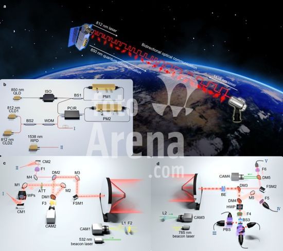
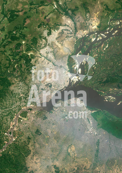
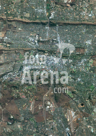
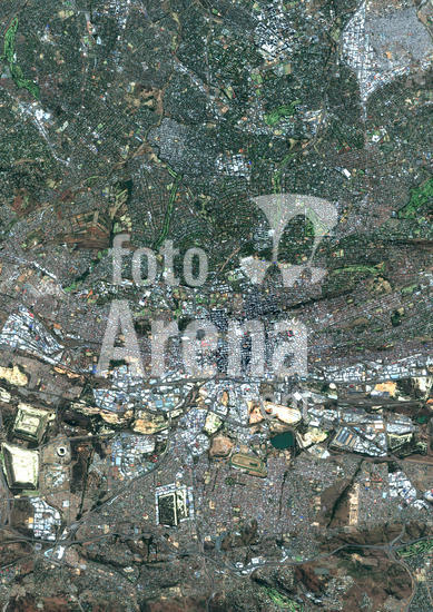
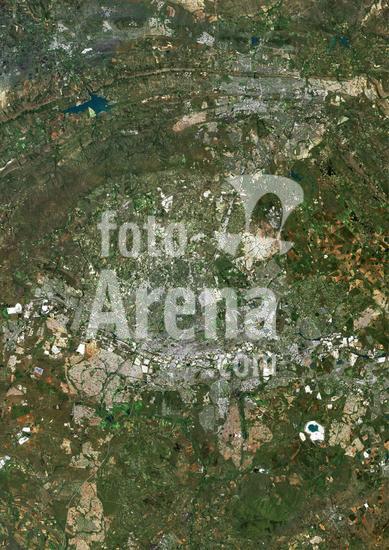
HEFEI, March 20, 2025 This image transmitted through quantum-secured communication between China and South Africa in a data transmission experiment shows the experimental site at Stellenbosch University, South Africa. An international team led by Chinese scientists have realized quantum-secured communication across over 12,900 kilometers between China and South Africa.. Using the Jinan-1 micro-nano satellite and compact ground stations, this new breakthrough in quantum technology demonstrates the potential for secure quantum communication on a global scale..TO GO WITH ''2nd LD-Writethru-China Focus: Chinese-led team achieves world's first 10,000-km quantum-secured communication'' (University of Science and Technology of China/Handout via Xinhua) (Credit Image: © Xu Haitao/Xinhua/Zuma Press/Fotoarena)
DC
20250320_zaf_x99_109 HEFEI, March 20, 2025 This image of the Great Wall is used in a data transmission experiment through quantum-secured communication between China and South Africa. An international team led by Chinese scientists have realized quantum-secured communication across over 12,900 kilometers between China and South Africa.. Using the Jinan-1 micro-nano satellite and compact ground stations, this new breakthrough in quantum technology demonstrates the potential for secure quantum communication on a global scale..TO GO WITH ''2nd LD-Writethru-China Focus: Chinese-led team achieves world's first 10,000-km quantum-secured communication'' (University of Science and Technology of China/Handout via Xinhua) (Credit Image: © Xu Haitao/Xinhua/Zuma Press/Fotoarena)
DC
20250320_zaf_x99_108 HEFEI, March 20, 2025 This schematic diagram shows the quantum key distribution experiment of the Jinan-1 micro-nano satellite. An international team led by Chinese scientists have realized quantum-secured communication across over 12,900 kilometers between China and South Africa.. Using the Jinan-1 micro-nano satellite and compact ground stations, this new breakthrough in quantum technology demonstrates the potential for secure quantum communication on a global scale..TO GO WITH ''2nd LD-Writethru-China Focus: Chinese-led team achieves world's first 10,000-km quantum-secured communication'' (University of Science and Technology of China/Handout via Xinhua) (Credit Image: © Xu Haitao/Xinhua/Zuma Press/Fotoarena)
DC
913_03_PO07348 Color satellite image of Brazzaville, capital city of the Republic of the Congo, and Kinshasa, capital city of the Democratic Republic of the Congo. Brazzavile is located on the north shore of the Congo River, while Kinshasa lies on the south shore. Image collected on September 19, 2017 by Sentinel-2 satellites.
DC
913_03_PO07338 Color satellite image of Pretoria, capital city of South Africa. Image collected on June 11, 2017 by Sentinel-2 satellites.
DC
913_03_PO07337 Color satellite image of Johannesburg, South Africa. Image collected on June 11, 2017 by Sentinel-2 satellites.
DC
PAR428478 SOUTH AFRICA. Kurland village, near Plettenberg bay. 2012.
DC
917_05_WHA_185TH Image is a nadir camera view of the area around Kruger National Park in northeastern South Africa. Aug. 18, 2010. Satellite image.
DC
917_05_015033 Cape Town and Cape of Good Hope, South Africa, in foreground of perspective view generated from Landsat satellite image and elevation data from the Shuttle Radar Topography Mission (SRTM). Credit NASA. Science Earth Geology
DC
913_03_po03727 South Sudan, Relief Map with Border and Mask
DC
913_03_po03725 South Africa, Relief Map with Border and Mask
DC
913_03_po03680 Lesotho, Relief Map With Border and Mask
DC
913_03_PO02253 South Sudan, True Colour Satellite Image With Border
DC
913_03_PO02252 South Sudan, True Colour Satellite Image With Border and Mask
DC
913_03_PO02251 South Sudan, Relief Map with Border
DC
913_03_PO02250 South Sudan, Relief Map with Border and Mask
DC
913_03_PO02245 South Africa, True Colour Satellite Image With Border
DC
913_03_PO02244 South Africa, True Colour Satellite Image With Border and Mask
DC
913_03_PO02243 South Africa, Relief Map with Border
DC
913_03_PO02242 South Africa, Relief Map with Border and Mask
DC
913_03_PO01997 Lesotho, True Colour Satellite Image With Border
DC
913_03_PO01996 Lesotho, True Colour Satellite Image With Border and Mask
DC
913_03_PO01995 Lesotho, Satellite Image With Bump Effect, With Border
DC
913_03_PO01994 Lesotho, Satellite Image With Bump Effect, With Border and Mask
DC
913_03_PO01993 Lesotho, Relief Map With Border
DC
913_03_PO01992 Lesotho, Relief Map With Border and Mask
DC
913_03_PO01867 Guinea, True Colour Satellite Image With Border
DC
913_03_PO01865 Guinea, Relief Map With Border
DC
913_03_PO01344 Algeria, True Colour Satellite Image With Mask And Border. Algeria, true colour satellite image with mask and border. North is at top. Most of the coastal area is hilly, sometimes even mountainous. The area just south of the coast is fertile. Further south is the Atlas mountain range and the Sahara desert. Algiers, Oran and Constantine are the main cities.This image was compiled from data acquired by LANDSAT 5 & 7 satellites.
DC
913_03_PO01343 Algeria, True Colour Satellite Image With Border. Algeria, true colour satellite image with border. North is at top. Most of the coastal area is hilly, sometimes even mountainous. The area just south of the coast is fertile. Further south is the Atlas mountain range and the Sahara desert. Algiers, Oran and Constantine are the main cities.This image was compiled from data acquired by LANDSAT 5 & 7 satellites.
DC
913_03_PO01342 South Africa, True Colour Satellite Image With Mask And Border. South Africa, true colour satellite image with mask and border. This image was compiled from data acquired by LANDSAT 5 & 7 satellites.
DC
913_03_PO01341 South Africa, True Colour Satellite Image With Border. South Africa, true colour satellite image with border. This image was compiled from data acquired by LANDSAT 5 & 7 satellites.
DC
913_03_PO01340 South Africa, True Colour Satellite Image. South Africa, true colour satellite image. This image was compiled from data acquired by LANDSAT 5 & 7 satellites.
DC
913_03_PO01311 Red Sea, Middle East, True Colour Satellite Image. True colour satellite image of the Red Sea, a seawater inlet of the Indian Ocean, lying between Africa and Asia. The connection to the ocean is in the south through the Gulf of Aden. In the north, there is the Gulf of Aqaba and the Gulf of Suez, leading to the Suez Canal. Bordering countries are Egypt, Israel, Jordan, Saudi Arabia, Yemen, Djibouti, Eritrea and Sudan. Composite image using LANDSAT 5 data.
DC
913_03_PO01270 Saloum Delta And Gambia River, Western Africa, True Colour Satellite Image. True colour satellite image of the Saloum Delta in Senegal and the Gambia River in Gambia. The Saloum Delta is protected as Saloum Delta National Park. The river basin lies within the Kingdom of Saloum. North of Saloum Delta is Dakar, the capital city of Senegal, located on the Cape Verde Peninsula on the Atlantic coast. South is the Gambia river which runs westward to the Atlantic Ocean at the city of Banjul. Composite image using LANDSAT 5 data.
DC
913_03_PO00460 Vredefort Meteor Impact Crater, South Africa, True Colour Satellite Image. True colour satellite image of Vredefort impact structure, South Africa (diameter : 140 km). Composite image of LANDSAT data taken on 7 April 1991 and 30 April 1991.
DC
913_03_PO00451 Saltpan Meteor Impact Crater, Pretoria, South Africa, True Colour Satellite Image. True colour satellite image of Saltpan impact structure, Pretoria, South Africa (diameter : 1,13 km). Image taken on 7 September 1991 using LANDSAT data.
DC
913_03_PO00422 Piton De La Fournaise Volcano In 3D, Reunion Island, French Overseas, True Colour Satellite Image. Piton de la Fournaise, Reunion, true colour satellite image. 3D satellite view of the Piton de la Fournaise (2631m), one of the world's most active volcanoes, located on the South East part of Reunion Island, in the Indian Ocean. Image using LANDSAT data.
DC
913_03_PO00404 Piton De La Fournaise Volcano, Reunion Island, French Overseas, True Colour Satellite Image. Piton de la Fournaise, Reunion island, French overseas, true colour satellite image. Piton de la Fournaise (2631m), one of the world's most active volcanoes, is located on the South East part of Reunion Island, in the Indian Ocean. Image taken on 19 June 2000 using LANDSAT data. Print size 30 x 30 cm.
DC
913_03_PO00366 Sand Tempest, Sahara, True Colour Satellite Image. Sand tempest off Morocco and Mauritania, true colour satellite image. The Canaries Islands are on the North part of the image, and Cape Verde Islands on the South part. Image taken on 2 March 2003 using LANDSAT data.
DC
913_03_PO00333 Kilimandjaro, Tanzania, True Colour Satellite Image. Portions of Kenya and Tanzania, Africa, can be seen in this image. The peak of Kilimanjaro is on the right; the mountain is flanked by the plains of Amboseli National Park to the north and the rugged Arusha National Park to the south and west. Image taken on 25 February 1987 using LANDSAT data.
DC
913_03_PO00310 Rub Al Khali Desert, Saudi Arabia, True Colour Satellite Image. Rub Al Khali, a sand desert South East of Saudi Arabia ; sand dunes are sculptured and moved by the winds, in blue the argillakeeous subsoil, and in white the salt crusts left out by the oueds in the rainy season.
DC
913_03_PO00309 Desert Erg Iguidi, Algeria, True Colour Satellite Image. True colour satellite image of Erg Iguidi, a sand desert between Algeria and Mauritania. The 250m wide dunes lay in the South on a sand plain, and in the North on a blakek sandstone area. The light blue areas are calcareous and salt crusts left out from the evaporation of the oueds' water. Image taken on 29 March 1987 using LANDSAT data.
DC
913_03_PO00308 Kalahari Desert, Namibia, True Colour Satellite Image. True colour satellite image of the Kalahari desert, at the frontier between Namibia and South Africa. The dunes are red-coloured by iron oxyds. The blue dots are argillakeeous basins, still filled with water. The white dotes are salted basins that show how dry this plakee is. Image taken on 3 March 1989 using LANDSAT data.
DC
913_03_PO00199 Cape Town, South Africa, True Colour Satellite Image. Cape Town, South Africa. True colour satellite image of the city of Cape Town. Composite of 2 images taken on 3 June 2002 & 13 June 2000, using LANDSAT 7 data.
DC
913_03_PO00190 Johannesburg, South Africa, True Colour Satellite Image. Johannesburg, South Africa. True colour satellite image of the city of Johannesburg, taken on 1 July 2002, using LANDSAT 7 data.
DC
913_03_PO00160 Cape Town, South Africa, True Colour Satellite Image. Cape Town, South Africa. True colour satellite image of the city of Cape Town. Composite of 2 images taken on 3 June 2002 and 13 June 2000, using LANDSAT 7 data.
DC
913_03_PO00064 South Africa, True Colour Satellite Image With Mask. South Africa, true colour satellite image with mask. This image was compiled from data acquired by LANDSAT 5 & 7 satellites.
DC
913_03_PO00058 Near East, True Colour Satellite Image. Near East, true colour satellite image. The deserts (light brown) of Saudi Arabia dominate this image. The Persian Gulf (upper right) and the Red Sea (lower centre) border the Arabian Peninsula that has mountains (dark brown) on its western coast. The River Nile (lower center) has a delta on Egypt's Mediterranean Sea coast, south of the island of Cyprus. Israel's coast (green) is below and right of Cyprus. Across top, mountains make up Iran (right) and Turkey (left). A green area (upper centre) lies in Iraq. This image was compiled from data acquired by LANDSAT 5 & 7 satellites.
DC
913_03_PO00055 Algeria, True Colour Satellite Image With Mask. Algeria, true colour satellite image with mask. North is at top. Most of the coastal area is hilly, sometimes even mountainous. The area just south of the coast is fertile. Further south is the Atlas mountain range and the Sahara desert. Algiers, Oran and Constantine are the main cities.This image was compiled from data acquired by LANDSAT 5 & 7 satellites.
DC
913_03_PO00016 Asia, True Colour Satellite Image. Asia. True colour satellite image centred on Asia, with nearly all of Africa (down left) and Europe (upper left) seen. This image shows the curvature of the Earth, with north-south lines converging towards top. The terrain of Asia varies from deserts (brown, central and southern Asia), to tropical rainforests (dark green, South-East Asia and the Malay Archipelago), to grasslands, forests and tundra (lighter green, northern Asia), and mountain ranges (centre). Also seen is the Arctic (top), Alaska (top right), and the Pacific Ocean (right) and Indian Ocean (lower left). The image used data from LANDSAT 5 & 7 satellites.
DC
913_03_PO00009 Globe South Pole, True Colour Satellite Image. Earth. True colour satellite image of the Earth, centred on Antarctica. The South Pole is at centre. Antarctica is a frozen continent, permanently covered in snow and ice. Surrounding Antarctica are the waters of the Southern Ocean, mixing with the Atlantic Ocean (upper centre), the Pacific Ocean (lower left) and the Indian Ocean (centre right). Around the edge of the hemisphere is New Zealand (lower centre), Australia (lower right), and the southern parts of Africa (upper right, the island of Madagascar is also seen) and South America (upper left). The image used data from LANDSAT 5 & 7 satellites. Print size 42x42cm.
DC
913_03_PO00008 Globe Africa, True Colour Satellite Image. Earth. True colour satellite image of the Earth, centred on Africa. North is at top. Water is blue, vegetation is green, arid areas are brown, and snow and ice are white. Both land and ocean floor topography are shown. The terrain of Africa varies from rock and sand (grey and brown) in the Sahara in North Africa, to tropical rainforests (dark green) in Western and Central Africa, to savannah and plains (brown and green) in southern and eastern Africa. Surrounding Africa (clockwise from top) is Europe and the Mediterranean, the Arabian Peninsula, the Indian Ocean and the island of Madagascar, and the Atlantic Ocean. At the edge of the globe are India (upper right), Antarctica (bottom), South America (lower left) and Greenland (top). The image used data from LANDSAT 5 & 7 satellites. Print size 42x42cm.
DC
913_03_PO00006 Globe Asia, True Colour Satellite Image. Earth. True colour satellite image of the Earth, centred on Asia. The North Pole is at upper centre. Water is blue, vegetation is green, arid areas are brown, and snow and ice are white. Both land and ocean floor topography are shown. The terrain of Asia varies from deserts (brown, central and southern Asia), to tropical rainforests (dark green, South- East Asia), to plains, forests and tundra (lighter green, northern Asia), and mountain ranges (lower centre). Surrounding mainland Asia (clockwise from top) is the Arctic Ocean (with Greenland and North America beyond), the Pacific Ocean, the Malay Archipelago and northern Australia, the Indian Ocean, north-eastern Africa, and Europe. The picture is a composite created from thousands of separate images recorded by LANDSAT 5 & 7 satellites. Print size 42x42cm.
DC
913_03_PO00005 Globe South America, True Colour Satellite Image. Earth. True colour satellite image of the Earth, centred on South America. North is at top. Water is blue, vegetation is green, arid areas are brown, and snow and ice are white. Both land and ocean floor topography are shown. The terrain of South America is marked by the Andes mountains along the western coast, tropical rainforests (dark green) in the Amazon river basin in the north, and swamps and plains (lighter green) in the south. Surrounding South America (clockwise from upper left) is North America and the Caribbean islands, the Atlantic Ocean (right) and the Pacific Ocean (left). Parts of Greenland, Europe, Africa and Antarctica are also seen on the edges of the globe. The image used data from LANDSAT 5 & 7 satellites. Print size 42x42cm.
DC
913_03_PO00004 Globe North America, True Colour Satellite Image. Earth. True colour satellite image of the Earth, centred on North America. The North Pole is at upper centre. Water is blue, vegetation is green, arid areas are brown, and snow and ice are white. Both land and ocean floor topography are shown. The terrain of North America is marked by mountain ranges on the western coast, deserts in the south-west, and large lakes in the north-east. The shades of green vary, showing central plains, marshes in the far north, swamps in the south-east and forests in the north-west. Surrounding North America (clockwise from top) is the Arctic Ocean, Greenland, and the Atlantic Ocean (beyond which are Asia, Europe and Africa), South America and the Pacific Ocean. The image used data from LANDSAT 5 & 7 satellites. Print size 42x42cm.
DC
HISL001_EC174 Imaginative bird's eye view of Italian peninsula looking south from the Alps. View shows Mediterranean Islands, Adriatic Coast, and North Africa. The 19th century image compares with contemporary satellite images.
DC

Total de Resultados: 57

Página 1 de 1